
France has lots of exotic landscapes. People from outside the country tend to think of the mostly flat region, around Paris, when they think of France geography. Because that is what they have seen.
Or maybe the hilly fields of Normandy.
But a sprawling mass of land in the center of the country, known as the Massif Central, has lots of dramatic up-and-down scenery.
Even this part of southern France, generally thought to be made up almost entirely of rollings hills, right on down to the sea, has surprising terrain.
We discovered that, anew, when we stumbled over what we are going to call the Grand Canyon of the Languedoc.
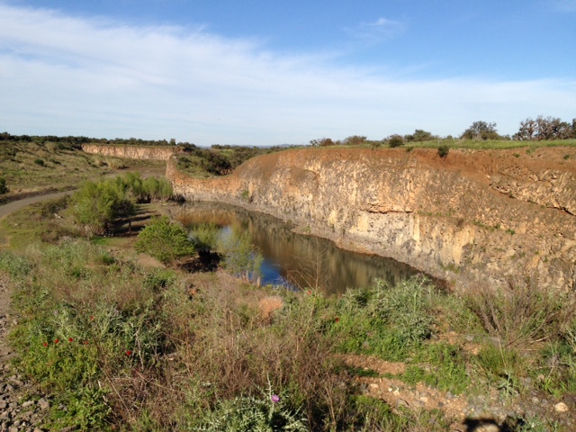
Odd thing. We had driven around that patch of land dozens of times but had never seen what was down there. To wit: A sunken area several square miles in area and bounded nearly all around by tall cliffs.
We found this mostly because of curiosity concerning a steep field we could see on one of our regular walks.
From Day 1, I wondered what was on the other side of the large grassy rectangle, which ran almost to the top of a forested ridge.
I had looked at Google maps and it appeared that if we could push through the narrow part of the trees at the top of the hill, beyond this grassy area … that we would come out near the southern end of the the area’s “aerodrome” — an actual landing strip on a flat, long, grassy area. Like you see in Africa when going on safari.
So, we went up the hill (I didn’t want to do this alone, in case I slipped, or fell), and the field we were interested in … wasn’t quite as steep as it looked from below. But it has to be a former vineyard. Why else would it otherwise be treeless? They must have cleared out the trees, put in vines, then later decided it was too steep for grapes.
Anyway, we went up to the top of the field and pushed through about 40 yards of trees and undergrowth and emerged on a primitive path of black pumice rocks, offering a laborious choice left or right.
And just the other side of the path, where a fence has been knocked down is … an enormous hole in the ground!
You find yourself saying, “What the hell?” Because we have not seen anything like it in this region.
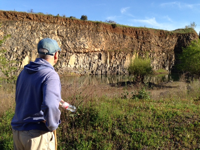
We were looking over the edge of a cliff, at least 60 feet high, certainly high enough to be fatal if we slipped over the edge. Over to the right the cliffs were even steeper, perhaps 100 feet from canyon floor to the sheer edge of the cliff.
Somehow, at some time in the past, the land in the bottom had slipped away from what now are cliffs, leaving a fairly wide (a mile in some places) fairly flat canyon surrounded on three sides by these cliffs.
Our choices were to go right, through what seemed like a more densely forested area, and see if we arrived at the aerodrome fairly quickly … or go left, where we could see the cliff dropped off a bit and the land on the bottom rose to meet it. Go down into the canyon, that is. (I thought I saw a place, across the canyon and at the far end right end, where we might be able to climb back out.)
We chose the canyon route, and we scrabbled downhill and soon were on the mostly flat bottom of the canyon, with the bare cliffs rearing up around us. Mostly tinted a sort of red, from iron ore, I think.
We were walking through low grassy undergrowth when eventually we hit a track, which we could not see from up on the cliff.
The gravel track apparently is used occasionally by motor vehicles. Eventually, it took us past a couple of “ponds” that must have been the “reservoirs” a long-time resident of our town had told us were south of us.
It was midday, but no one else was in the canyon, on the valley floor. A few birds circled above. We were thinking that wild life could live in this big hole in the ground, with its lack of buildings and people.
The most powerful impression, as we listened to the wind, was having a sense of being far, far from civilization. The human touch was limited to the rough truck path and then to a pair of long, narrow ponds — which could, yes, be a natural occurrence.
After about a half hour, we climbed out of the western side of the canyon, via a zigzag path, and found a asphalt road that soon linked with the main route to our town.
We followed that for a bit, then took off across the short grass of the aerodrome, which seems to be used mostly by operators of small drones.
In a bit over two hours, we had climbed the steep hill, crossed over into the canyon and made our way back out. It was quite the unexpected journey, and we wonder if even the local folks are aware of what is down there.
This isn’t the lush green of the vineyards. It is a very interesting land formation, one we assumed could not exist in the area, one that may date back to the volcanic history of the area — long, long ago.
0 responses so far ↓
There are no comments yet...Kick things off by filling out the form below.
Leave a Comment