
And now the tongue-in-cheek map to accompany the Arab Spring, which pretty much passed right over the fat and happy UAE.
This is a quite clever bit of work, and I will endeavor to help explain it, for those of you who may not have been paying close attention to the upheaval/tumult this year in much of the Arab world.
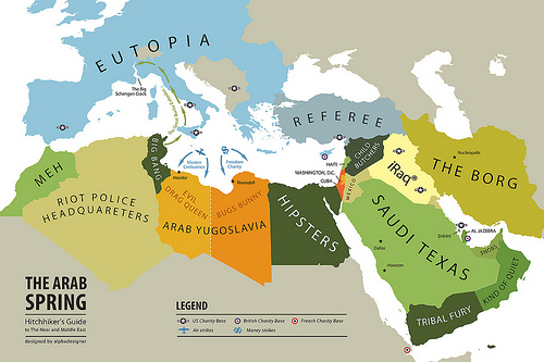
Here we go:
First, let’s give credit: The author of this is alphadesigner which appears to be a guy named Yanko Tsvetkov who lives in London, according to his home page. He also appears to have done a couple of dozen maps under the heading of “Mapping Stereotypes”, which you may peruse here.
As for his Arab Spring map …
We begin with the sprawl of “Eutopia”, that is, Europe. This is perhaps irony (pretty much required among the 30-and-under set), but the idea is that from the vantage point of lands where despots rule, the generally free and elected and competent governments (where Presidents for Life are currently unknown), Eutopia looks pretty good.
(Curious that Switzerland and most of the former Yugoslavia and all of the former Soviet republics are pictured in gray.)
So, starting on the left of North Africa, we find Morocco listed as the nation of “Meh” — slang for “who cares” or “I’m indifferent.” No shooting in Morocco, but some changes suggested by the generally popular king there.
As we move right, we come to “Riot Police Headquarters”, which is Algeria, and presumably refers to Algeria quashing what little dissent has gone on there and its intent to keep it that way.
Next, is “Big Bang”, which is Tunisia — where the first revolt against the government began, setting the stage for what followed this year.
Then we come to Libya, which is still smoldering and he prefers to call “Arab Yugoslavia.” At the time of the map, Muammer Qaddafi apparently was still in charge of the western portion of the country, which he has labeled “Evil Drag Queen” in honor of Qaddafi’s, um, curious outfits. The eastern half of “Arab Yugoslavia” has “Bugs Bunny” attached to it, and I am not sure what he’s getting at there. “What’s up, Doc?”
Note, too, the two cities listed … on the left is “Mordor”, which is Tripoli, where Qaddafi stuck it out until the past few weeks, and on the right is “Rivendell”, which is Benghazi, where the rebels were based. Mordor and Rivendell are two important cities in the “Lord of the Rings” trilogy; Mordor was the realm of the evil lord Sauron; Rivendell was the home of the powerful (and good-guy) Elves.
Next is “Hipsters”, which is Egypt. I suppose this is an homage to the uprising there, which had that “idealistic college student” feel to it, at least in Tahrir Square.
Let’s go up the eastern edge of the Mediterranean. Up next is “Cuba” which is the Gaza Strip, run by the anti-West Palestinian party named Hamas. Note the arrow to “Washington DC” … which is Jerusalem/Israel. Not that the U.S. is known as pro-Israel, or anything.
Above that is “Haiti” (Lebanon, prone to disastrous events), and then comes “Child Butchers”, which is Syria, still in chaos, and above that is “Referee”, which is Turkey, which has been trying to negotiate an end to hostilities in various countries.
Now we shift to the Arabian Peninsula.
“Mexico” is Jordan, and in terms of being poor and generally troubled, that’s pretty on.
The big country to the right (east) of Jordan is “Saudi Texas” or Saudi Arabia, and the cities denoted as “Dallas” and “Houston” correspond to the Saudi cities of Medina and Mecca, which the Saudis would not find amusing.
South of Saudi is “Tribal Fury”, which would be Yemen, which is a complete mess, and next to Yemen is “Kind of Quiet”, which is sleepy Oman.
Above “Kind of Quiet” is “Snobs” … which is the UAE! (Can we have a shoutout to high per-capita incomes?)
Then, as we work our way up the Gulf, we see “Al Jazeera” (Qatar, home to the famous cable network) and “Shhh”, which is Bahrain, where a major U.S. naval base is located and, the mapmaker seems to suggest, we are looking too closely at the government versus Shias problems.
At the head of the Gulf is “iRaq”(Iraq), presumably mocking the way some Americans pronounce the country’s name (EYE -rack). And to the right is “The Borg” which is Iran. I didn’t get the “Borg” reference at all and had to look it up (not being a fan of Star Trek movies) … and found that it refers to an evil race of “cybernetic organisms”. Iran, take a bow!
The one city denoted is called “Nucleopolis” (Tehran), referring to Iran’s pursuit of an atomic weapon.
And some of the small stuff:
“The Schengen Crack” corresponds with the mouth of the Rhone River, in southern France, and presumably applies to countries that are signatories to the Schengen Agreement, and this perhaps is meant to illustrate European ambivalence over the Arab Spring.
The arrow leading from “Big Bang” (Tunisia) to France that is labeled “The Great Burka Exodus” … refers to France banning the female form of attire favored by conservative Muslims.
The two curved arrows above “Arab Yugoslavia” (Libya) … the one of the left is entitled “Missions Civilisatrice” which is “civilizing mission” in French, an homage to France’s early support of the rebels (and the plane is meant to depict air strikes). And the curved arrow on the right is labeled “Freedom Charity”, and a “charity” in British English is a needy group receiving money, hence the dollar signs indicating British (and perhaps American) cash sent to the rebels’ side of Libya.
Got all that? I’m bushed.
Who knew that a map could be so complicated in an amusing way?
0 responses so far ↓
There are no comments yet...Kick things off by filling out the form below.
Leave a Comment